Mosaicking Grib files with additional dimension
In this page will be presented how to mosaic Grib data. These data represents the wind amplitude for the x and y directions on the sea surface of all the world. As you can see, the steps for configuring the mosaic are very similar to those of the NetCDF mosaic.
Check the indexer
Navigate to the
%TRAINING_ROOT%/geoserver_data/coverages/REGIONAL/wind/indexer.xmlfile and open it.At the end of the file you should have a parameters section like this:
<parameters>
    <parameter name="AuxiliaryFile" value="_wind.xml" />
    <parameter name="AbsolutePath" value="true" />
</parameters>
Configuring the Grib mosaic in GeoServer
Look at the
%TRAINING_ROOT%/geoserver_data/coverages/REGIONAL/wind. The folder contains several files:- indexer.xml: An XML file containing the Grib ImageMosaic index definition previously seen.
- _wind.xml: An XML file representing the Grib ancillary file to be shared by all the granules.
- datastore.properties: A text file containing the connection parameters to an external Postgres database.
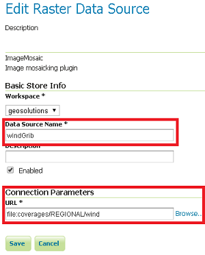
From the GeoServer Administration GUI, go to the Stores > Add new Store page and configure a new ImageMosaic datastore.
Insert windGrib as Data Source Name and file:coverages/REGIONAL/wind as URL

Note
Notice that the ImageMosaic plugin requires the folder name. Notice also that since the dataset is physically located under the ${GEOSERVER_DATA_DIR} you can use a relative path.
Note
For Postgres version lower than 9.2.3 the following parameter must be added to the datastore.properties file:
create\ database\ params=WITH\ TEMPLATE\=template_postgis
(Specifying the proper postgis template. In this example: template_postgis).
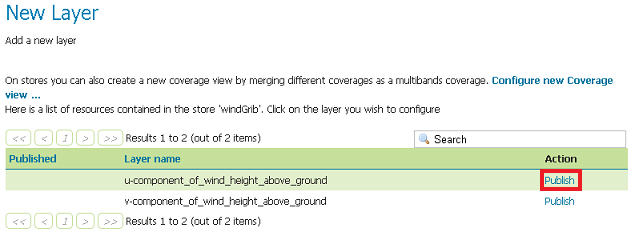
Select the first layer u-component_of_wind_height_above_ground

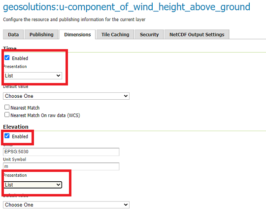
On the Dimensions tab, configure the time and elevation dimensions

Click on the save button when done
Repeat the Layer configuration steps to add the other layer contained within the windGrib store: v-component_of_wind_height_above_ground
Customizing GRIB cache directory location
When accessing a Grib file on GeoServer for the first time, by default two additional files are created. These files have the same name of the grib file and also the following extensions:
- .ncx
- .gbx9
Those files are generated automatically by the internal Java low level libraries at the first access to the input data or if they have been removed. By default on GeoServer, those files are created in the same directory of the Grib file, but this could lead to an exception if the directory is not writable. This behaviour can be avoided by setting a Java parameter called GRIB_CACHE_DIR with the path to a writable directory where the .ncx and .gbx9 files will be stored.
In case you need to specify a different Grib cache location:
Check if your
setenv.bathas the following property set in the JAVA_OPTS section and update/add it with a new location:-DGRIB_CACHE_DIR=PATH/TO/GRIB_CACHE_DIR
