
Frequently Asked Questions
WMS GetMap request throws a rendering exception
This usually happens when GeoServer can’t decide automatically which attribute of the complex feature type is the default geometry.
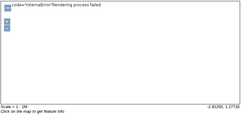
If that’s the case, the result of a WMS GetMap request will produce a result similar to this one:
... and the log of GeoServer should contain a stack trace similar to this one:
org.geoserver.platform.ServiceException: Rendering process failed
  at org.geoserver.wms.map.RenderedImageMapOutputFormat.produceMap(RenderedImageMapOutputFormat.java:610)
  at org.geoserver.wms.map.RenderedImageMapOutputFormat.produceMap(RenderedImageMapOutputFormat.java:269)
  at org.geoserver.wms.map.RenderedImageMapOutputFormat.produceMap(RenderedImageMapOutputFormat.java:136)
  at org.geoserver.wms.GetMap.executeInternal(GetMap.java:720)
  at org.geoserver.wms.GetMap.run(GetMap.java:300)
  at org.geoserver.wms.GetMap.run(GetMap.java:123)
  ...
Caused by: java.lang.NullPointerException
  at org.geotools.renderer.lite.StreamingRenderer.findGeometry(StreamingRenderer.java:2861)
  at org.geotools.renderer.lite.StreamingRenderer.access$100(StreamingRenderer.java:182)
  at org.geotools.renderer.lite.StreamingRenderer$RenderableFeature.getShape(StreamingRenderer.java:3142)
  at org.geotools.renderer.lite.StreamingRenderer.processSymbolizers(StreamingRenderer.java:2707)
  at org.geotools.renderer.lite.StreamingRenderer.processFeature(StreamingRenderer.java:2596)
  at org.geotools.renderer.lite.StreamingRenderer.drawPlain(StreamingRenderer.java:2428)
  at org.geotools.renderer.lite.StreamingRenderer.processStylers(StreamingRenderer.java:1999)
  at org.geotools.renderer.lite.StreamingRenderer.paint(StreamingRenderer.java:861)
  at org.geoserver.wms.map.RenderedImageMapOutputFormat.produceMap(RenderedImageMapOutputFormat.java:569)
  ... 114 more
If the complex feature type has an attribute that can be used as the default geometry, then we can overcome this situation by explicitly setting the default geometry attribute  in the App-Schema mappings file.
Consider the following complex feature represented in GML:
...
<wfs:member>
  <st:Station gml:id="station.st.1">
    <st:name>station1</st:name>
    <st:location>
      <st:name>Europe</st:name>
      <st:position>
        <gml:Point srsDimension="2" srsName="http://www.opengis.net/gml/srs/epsg.xml#4326">
          <gml:pos>1 -1</gml:pos>
        </gml:Point>
      </st:position>
    </st:location>
  </st:Station>
</wfs:member>
...
... in this case, attribute st:location\st:position of Station feature type should be used as the default geometry attribute:
...
<FeatureTypeMapping>
  <sourceDataStore>stations</sourceDataStore>
  <sourceType>stations</sourceType>
  <targetElement>st:Station</targetElement>
  <defaultGeometry>st:location/st:position</defaultGeometry>
  <attributeMappings>
      <AttributeMapping>
...
Configuration element <defaultGeometry>st:location/st:position</defaultGeometry> instructs GeoServer to use st:location/st:position attribute of Station feature type as the default geometry.
WMS GetMap throws a generic.sld style not found exception
When the following exception is returned by a WMS GetMap request:
<?xml version="1.0" encoding="UTF-8" standalone="no"?>
<!DOCTYPE ServiceExceptionReport
SYSTEM 'http://localhost:8080/geoserver/schemas/wms/1.1.1/WMS_exception_1_1_1.dtd'>
<ServiceExceptionReport version="1.1.1">
  <ServiceException>
    java.io.IOException: No such resource: generic.sld
       No such resource: generic.sld
  </ServiceException>
</ServiceExceptionReport>
... it means that a style needs to be selected for the complex feature layer.
When configuring a layer, GeoServer tries to automatically select a style based on the geometry type of the featrue type. If this automatic guess fails is up tot he user to select a valid style:
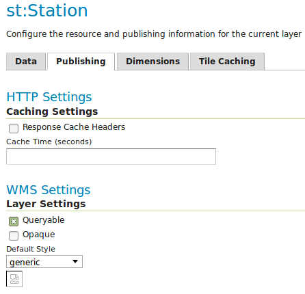
To overcome this issue just select a style that is compatible with the layer.
NULL name-spaces in GML output
It may happen that when querying a complex feature type and requesting a GML output that some name-spaces may appear as null:
...
<st:Station gml:id="station.13">
  <st:stationCode>ALS</st:stationCode>
  <st:stationName>Alessandria</st:stationName>
  <st:observation>
    <null:Observation gml:id="observation.1">
      <null:timestamp>2016-12-19T11:26:40Z</st:timestamp>
      <null:value>20.0</st:value>
      <null:parameter>
        <pr:Parameter gml:id="parameter.1">
          <pr:parameter>temperature</st:parameter>
          <pr:unit>C</st:unit>
        </pr:Parameter>
      </null:parameter>
    </null:Observation>
  </st:observation>
...
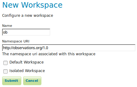
... the usual cause of this is that all the necessary names-paces were not defined in GeoServer. In this case three name-spaces are necessary:
To overcome this issue we just need to define the missing name-space http://observations.org/1.0 in Geoserver:
Is worth mentioning that when using HALE this issue should not happen, since HALE should automatically create all the necessary names-spaces.
Note
There was a long standing issue in GeoServer introducing null name-spaces in GML when virtual services were used, that issue as been fixed in recent versions of GeoServer.
Publishing the same complex feature type multiple times
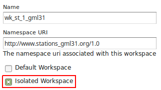
Sometimes the same complex feature type needs to be published multiple times with a different mapping and with the same name. This can be done in GeoServer using isolated workspaces functionality. To create an isolated workspace we just need to check the Isolated Workspace check-box:
The concept of isolated workspaces was introduced to allow multiple workspaces with the same name-space. The resources contained by an workspace can be referenced by the workspace prefix or by the workspace name-space. If two workspaces have the same name-space we need to have a way to prioritize which workspace should be considered. This is where isolated workspaces come in.
Consider the following image which shows to workspaces (st1 and st2) that use the same name-space (http://www.stations.org/1.0) and several layers contained by them:
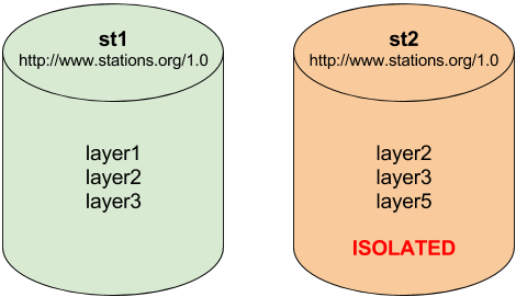
It is only possible to create two or more workspaces with the same name-space in GeoServer if at least one of them is marked as isolated, in the example above st2 is the isolated workspace. Consider the following WFS GetFeature requests:
http://<host>/geoserver/ows?service=WFS&version=2.0.0&request=DescribeFeatureType&typeName=layer2http://<host>/geoserver/st2/ows?service=WFS&version=2.0.0&request=DescribeFeatureType&typeName=layer2http://<host>/geoserver/ows?service=WFS&version=2.0.0&request=DescribeFeatureType&typeName=st1:layer2http://<host>/geoserver/st2/ows?service=WFS&version=2.0.0&request=DescribeFeatureType&typeName=st2:layer2http://<host>/geoserver/ows?service=WFS&version=2.0.0&request=DescribeFeatureType&typeName=st2:layer2http://<host>/geoserver/ows?service=WFS&version=2.0.0&request=DescribeFeatureType&typeName=layer5
The first request is targeting WFS global service and requesting layer2, this request will use layer2 contained by workspace st1. The second request is targeting st2 workspace WFS virtual service, layer2 belonging to workspace st2 will be used. Requests three and four will use layer2 belonging to workspace, respectively, st1 and st2. The last two requests will fail saying that the layer was not found.
Note
The rule of thumb is that resources (layers, styles, etc ...) belonging to an isolated workspace can only be retrieved when using the workspace virtual service and will only show up in that virtual service capabilities document.
JSON-LD and GeoJSON output formats support
GeoServer App-Schema plugin now supports JSON-LD and GeoJSON output formats on WFS GetFeature requests. GeoJSON is supported on the core meanwhile JSON-LD is supported via the JSON-LD community plugin.
- GeoJSON output format: application/json
- JSON-LD output format: application/ld+json
HTTP Filter body and mapping files are still XML based only.