
Exporting Complex features to an Isolated Workspace
Introduction
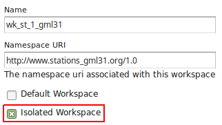
Sometimes the same complex feature type needs to be published multiple times with a different mapping and with the same name. This can be done in GeoServer using isolated workspaces |2018| functionality. To create an isolated workspace we just need to check the Isolated Workspace check-box:
The concept of isolated workspaces was introduced to allow multiple workspaces with the same name-space. The resources contained by an workspace can be referenced by the workspace prefix or by the workspace name-space. If two workspaces have the same name-space we need to have a way to prioritize which workspace should be considered. This is where isolated workspaces come in.
Consider the following image which shows to workspaces (st1 and st2) that use the same name-space (http://www.stations.org/1.0) and several layers contained by them:
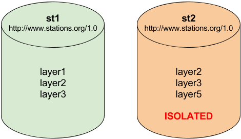
It is only possible to create two or more workspaces with the same name-space in GeoServer if at least one of them is marked as isolated, in the example above st2 is the isolated workspace. Consider the following WFS GetFeature requests:
http://<host>/geoserver/ows?service=WFS&version=2.0.0&request=DescribeFeatureType&typeName=layer2http://<host>/geoserver/st2/ows?service=WFS&version=2.0.0&request=DescribeFeatureType&typeName=layer2http://<host>/geoserver/ows?service=WFS&version=2.0.0&request=DescribeFeatureType&typeName=st1:layer2http://<host>/geoserver/st2/ows?service=WFS&version=2.0.0&request=DescribeFeatureType&typeName=st2:layer2http://<host>/geoserver/ows?service=WFS&version=2.0.0&request=DescribeFeatureType&typeName=st2:layer2http://<host>/geoserver/ows?service=WFS&version=2.0.0&request=DescribeFeatureType&typeName=layer5
The first request is targeting WFS global service and requesting layer2, this request will use layer2 contained by workspace st1. The second request is targeting st2 workspace WFS virtual service, layer2 belonging to workspace st2 will be used. Requests three and four will use layer2 belonging to workspace, respectively, st1 and st2. The last two requests will fail saying that the layer was not found.
Note
The rule of thumb is that resources (layers, styles, etc ...) belonging to an isolated workspace can only be retrieved when using the workspace virtual service and will only show up in that virtual service capabilities document.
Using Isolated Workspaces
On this exercise we’ll export modified Stations complex features to a new Isolated Workspace using a slightly different schema. An Isolated workspace can share the same namespace URI with other workspaces, but have its own name and any type definition outside the isolated workspace doesn’t affect its behavior. In this approach we can have Type names (namespace and name) without the name restriction from other workspaces as happens on regular GeoServer workspaces.
We will start adding a new BuildingSite Type definition with a geometry property to the schema:
<element name="BuildingSite" type="st:BuildingSiteType" substitutionGroup="gml:AbstractFeature" />

<complexType name="BuildingSiteType">
  <complexContent>
    <extension base="gml:AbstractFeatureType">
      <sequence>
        <element name="area" minOccurs="1" maxOccurs="1"
                 type="double" />
        <element name="station" minOccurs="0" maxOccurs="1"
                 type="st:StationPropertyType" />
        <element name="buildingArea" type="gml:GeometryPropertyType"
                 minOccurs="1" maxOccurs="1" />
      </sequence>
    </extension>
  </complexContent>
</complexType>

    <complexType name="BuildingSitePropertyType">
  <sequence minOccurs="0">
    <element ref="st:BuildingSite" />
  </sequence>
  <attributeGroup ref="gml:AssociationAttributeGroup" />
</complexType>
And then add a buildingSite property to the StationType definition using the new BuildingSitePropertyType:
<complexType name="StationType">
  <complexContent>
    <extension base="gml:AbstractFeatureType">
      <sequence>
        <element name="stationCode" minOccurs="1" maxOccurs="1"
                 type="string" />
        <element name="stationName" minOccurs="1" maxOccurs="1"
                 type="string" />
        <element name="observation" minOccurs="0" maxOccurs="unbounded"
                 type="st:ObservationPropertyType" />
        <element name="contactMail" minOccurs="0" maxOccurs="unbounded"
                 type="string"/>
        <element name="position" type="gml:GeometryPropertyType"
                 minOccurs="0" maxOccurs="1" />
        <element name="buildingSite" minOccurs="0" maxOccurs="1"
                 type="st:BuildingSitePropertyType" />
      </sequence>
    </extension>
  </complexContent>
</complexType>
We will name this new file as meteo-isolated.xsd, our final schema definition will be:
<?xml version="1.0"?>
<schema version="1.0"
        xmlns="http://www.w3.org/2001/XMLSchema"
        xmlns:xs="http://www.w3.org/2001/XMLSchema"
        xmlns:gml="http://www.opengis.net/gml/3.2"
        xmlns:st="http://www.stations.org/1.0"
        targetNamespace="http://www.stations.org/1.0"
        elementFormDefault="qualified" attributeFormDefault="unqualified">

  <import namespace="http://www.opengis.net/gml/3.2" schemaLocation="http://schemas.opengis.net/gml/3.2.1/gml.xsd" />

  <element name="Parameter" type="st:ParameterType" substitutionGroup="gml:AbstractGML" />

  <element name="Observation" type="st:ObservationType" substitutionGroup="gml:AbstractFeature" />

  <element name="Station" type="st:StationType" substitutionGroup="gml:AbstractFeature" />

  <element name="BuildingSite" type="st:BuildingSiteType" substitutionGroup="gml:AbstractFeature" />

  <complexType name="ParameterType">
    <complexContent>
      <extension base="gml:AbstractGMLType">
        <sequence>
          <element name="parameter" minOccurs="1" maxOccurs="1"
                   type="string" />
          <element name="unit" minOccurs="1" maxOccurs="1" type="string" />
        </sequence>
      </extension>
    </complexContent>
  </complexType>

  <complexType name="ObservationType">
    <complexContent>
      <extension base="gml:AbstractFeatureType">
        <sequence>
          <element name="timestamp" minOccurs="1" maxOccurs="1"
                   type="dateTime" />
          <element name="value" minOccurs="1" maxOccurs="1"
                   type="double" />
          <element name="parameter" minOccurs="1" maxOccurs="1"
                   type="st:ParameterPropertyType" />
          <element name="samplingStation" minOccurs="0" maxOccurs="1"
                   type="st:StationPropertyType" />
        </sequence>
      </extension>
    </complexContent>
  </complexType>

  <complexType name="StationType">
    <complexContent>
      <extension base="gml:AbstractFeatureType">
        <sequence>
          <element name="stationCode" minOccurs="1" maxOccurs="1"
                   type="string" />
          <element name="stationName" minOccurs="1" maxOccurs="1"
                   type="string" />
          <element name="observation" minOccurs="0" maxOccurs="unbounded"
                   type="st:ObservationPropertyType" />
          <element name="contactMail" minOccurs="0" maxOccurs="unbounded"
                   type="string"/>
          <element name="position" type="gml:GeometryPropertyType"
                   minOccurs="0" maxOccurs="1" />
          <element name="buildingSite" minOccurs="0" maxOccurs="1"
                   type="st:BuildingSitePropertyType" />
        </sequence>
      </extension>
    </complexContent>
  </complexType>

  <complexType name="BuildingSiteType">
    <complexContent>
      <extension base="gml:AbstractFeatureType">
        <sequence>
          <element name="area" minOccurs="1" maxOccurs="1"
                   type="double" />
          <element name="station" minOccurs="0" maxOccurs="1"
                   type="st:StationPropertyType" />
          <element name="buildingArea" type="gml:GeometryPropertyType"
                   minOccurs="1" maxOccurs="1" />
        </sequence>
      </extension>
    </complexContent>
  </complexType>

  <complexType name="ParameterPropertyType">
    <sequence minOccurs="0">
      <element ref="st:Parameter" />
    </sequence>
    <attributeGroup ref="gml:AssociationAttributeGroup" />
  </complexType>

  <complexType name="ObservationPropertyType">
    <sequence minOccurs="0">
      <element ref="st:Observation" />
    </sequence>
    <attributeGroup ref="gml:AssociationAttributeGroup" />
  </complexType>

  <complexType name="StationPropertyType">
    <sequence minOccurs="0">
      <element ref="st:Station" />
    </sequence>
    <attributeGroup ref="gml:AssociationAttributeGroup" />
  </complexType>

  <complexType name="BuildingSitePropertyType">
    <sequence minOccurs="0">
      <element ref="st:BuildingSite" />
    </sequence>
    <attributeGroup ref="gml:AssociationAttributeGroup" />
  </complexType>

</schema>
With this new schema we will publish the Station type (with same URI) on a new workspace making it isolated.
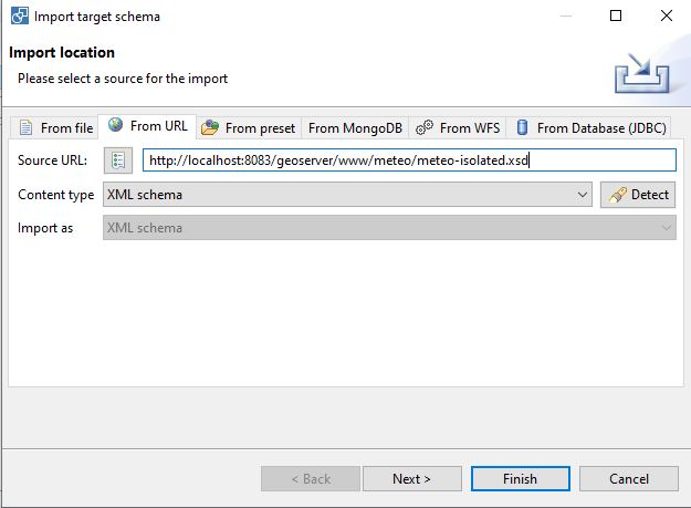
Import the http://localhost:8083/geoserver/www/meteo/meteo-isolated.xsd new schema, and click Finish:
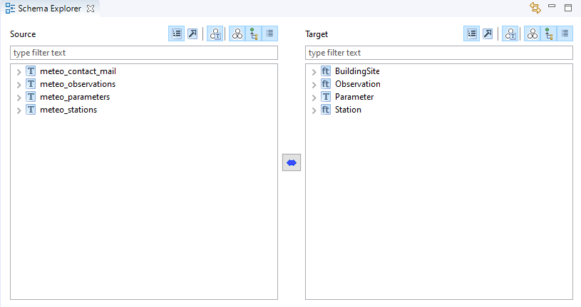
The imported types should now show the BuildingSite type:
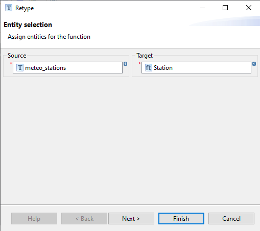
Select meteo_stations source type and Station target type, click the double arrow button and select ReType:
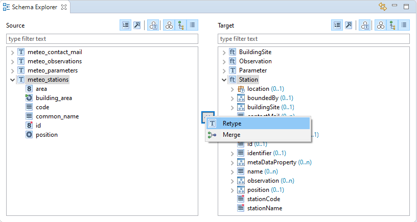
Click on Finish button:
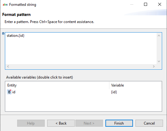
Select meteo_stations → id on source types and Station → id on target types and select Formatted String:
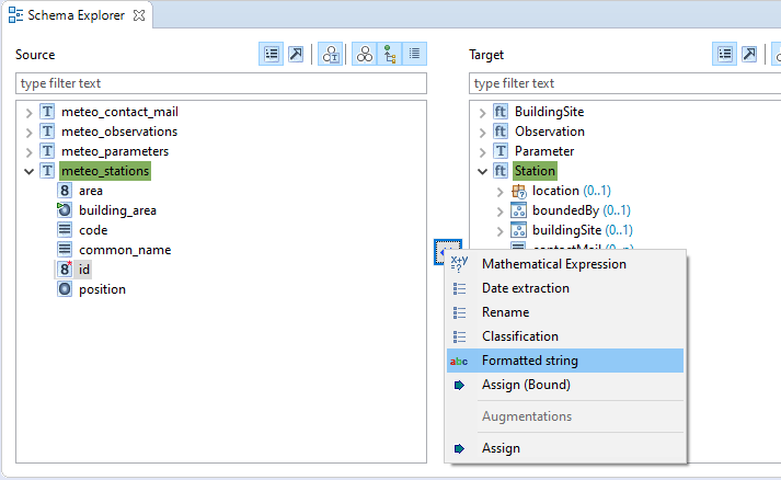
Click next:
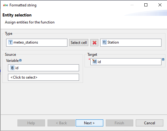
Write station.{id} and click Finish:
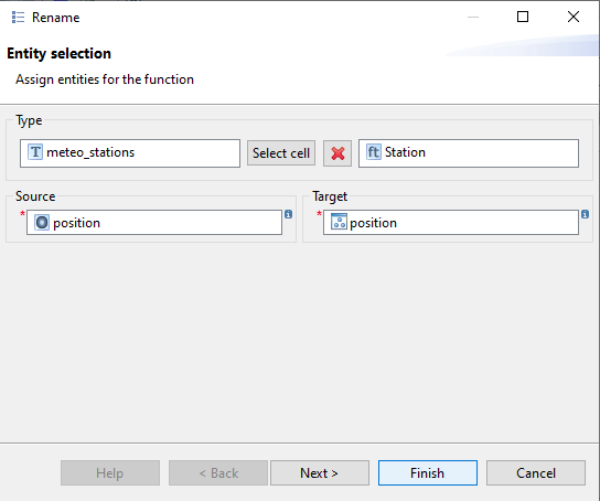
Select meteo_stations → position on source types and Station → position on target types, then click the double arrow button and select Rename:
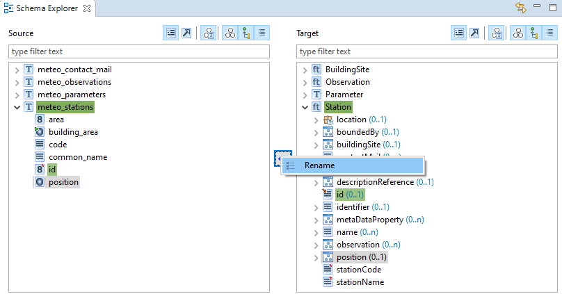
Click on Finish:
In the same way, apply Rename transformation for meteo_stations.code → Station/stationCode and meteo_stations.common_name → Station/stationName.
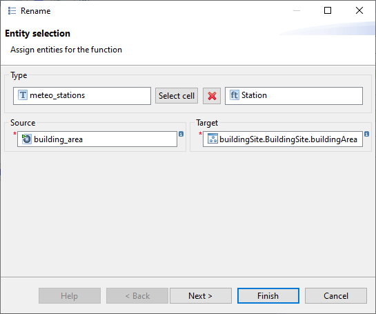
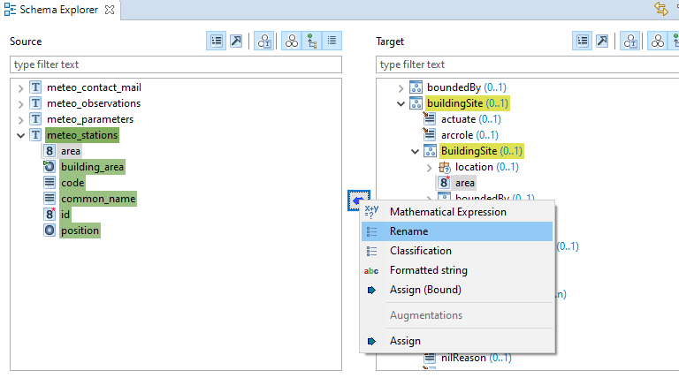
Now we will connect the nested feature attributes. Select meteo_stations.building_area on source types and Station/buildingSite/BuildingSite/buildingArea on target types, click on the double arrow button and select Rename. Click on Finish button:
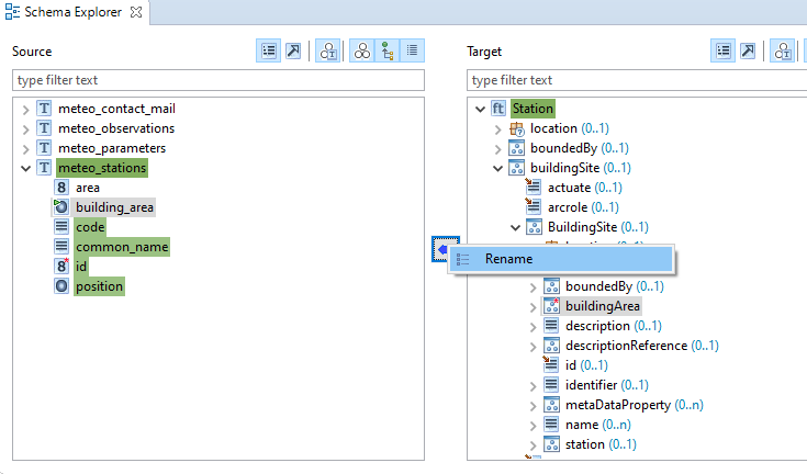
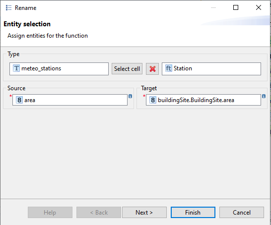
Now we will connect the nested feature attributes. Select meteo_stations.area on source types and Station/buildingSite/BuildingSite/area on target types, click on the double arrow button and select Rename. Click on Finish button:
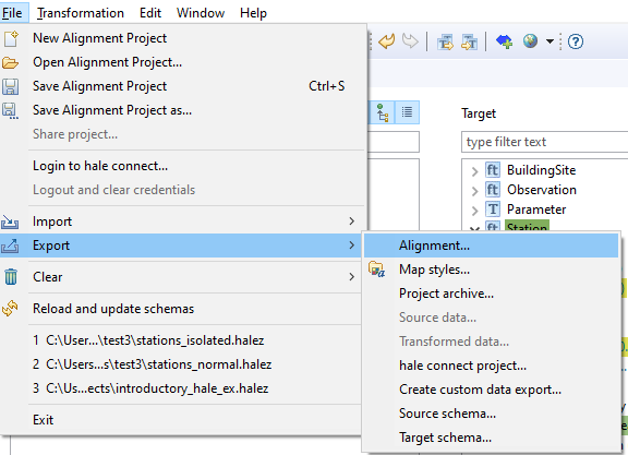
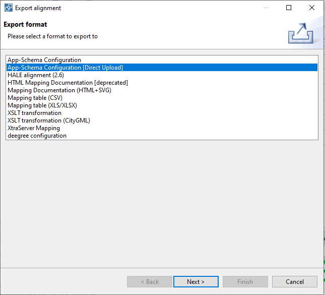
Let’s export this new mapping to Geoserver, on Hale main menu click on File → Export → Alignment, select App-Schema Configuration [Direct Upload]:
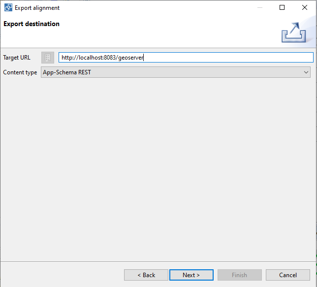
Write http://localhost:8083/geoserver on Target Url, click Next:
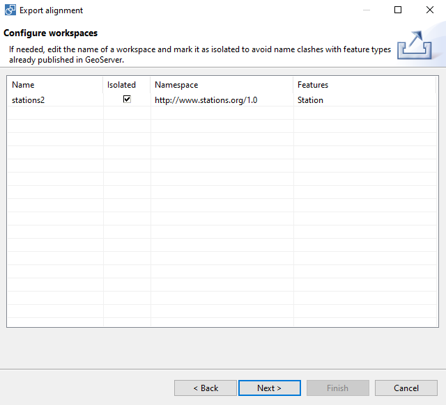
Change the workspace name to stations2, mark it as Isolated and click on Next button:
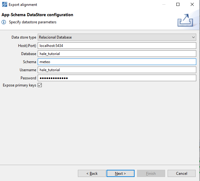
Select Relational Database, fill the database connection parameters and click on Next button:
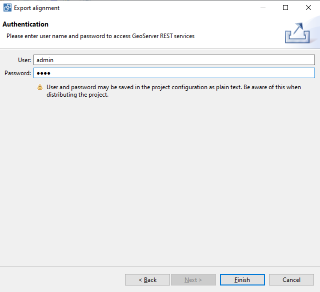
Fill the Geoserver authentication parameters and click on Finish button:
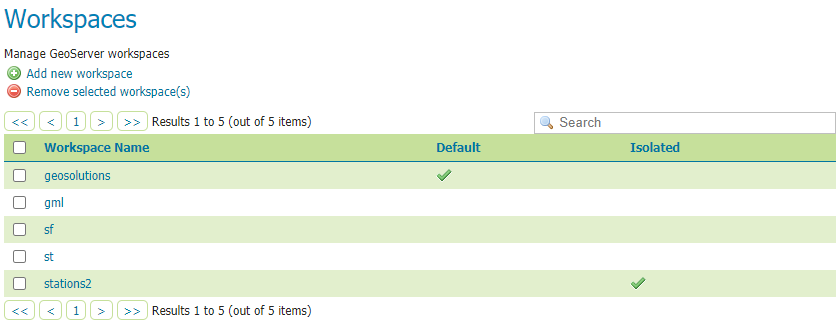
On GeoServer, go to Workspaces section and we should see the new isolated workspace available:
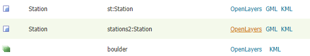
Go to Preview Layers GeoServer menu, locate stations2:Station layer and click on OpenLayers link:
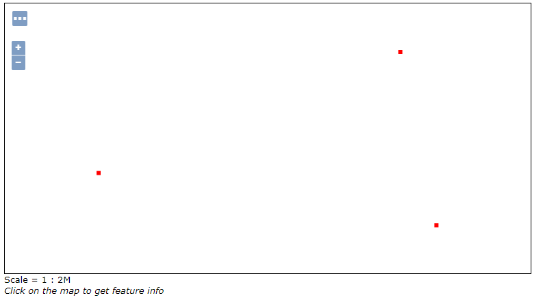
The layer preview will show the configured points on a preview map:
Set the default geometry
The BuildingSite type contains a geometry connected to the meteo_stations.building_area polygons. Now we will use App-Schema Default Geometry configuration for making these polygons the default geometry GeoServer WMS will draw (and WFS will use as well).
We will set the defaultGeometry XML attribute to define which property will be used as default geometry on GeoServer, writting the XPATH string pointing to the property (it could be a nested property). On our case we will set the default property to the stations2:buildingSite/stations2:BuildingSite/stations2:buildingArea XPATH:
<defaultGeometry>stations2:buildingSite/stations2:BuildingSite/stations2:buildingArea</defaultGeometry>
Let’s open the Training-Geoserver-2.17.x-V3geoserver_datadatastations2meteo-isolatedmeteo-isolated.appschema mapping file and add a this new line after the <targetElement> attribute:
<FeatureTypeMapping>
  <mappingName>Station-c3ce3917-81b2-45ca-b963-16dfdfa04517</mappingName>
  <sourceDataStore>dataStore</sourceDataStore>
  <sourceType>meteo_stations</sourceType>
  <targetElement>stations2:Station</targetElement>
  <defaultGeometry>stations2:buildingSite/stations2:BuildingSite/stations2:buildingArea</defaultGeometry>
  <attributeMappings>
    <AttributeMapping>
      <targetAttribute>stations2:Station</targetAttribute>
      <idExpression>
        <OCQL>strConcat('station.', id)</OCQL>
      </idExpression>
    </AttributeMapping>
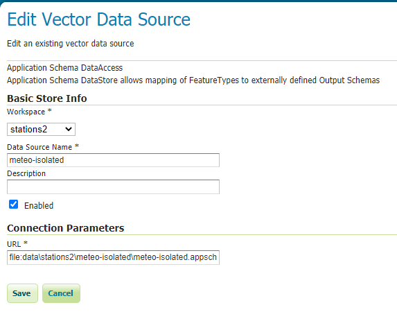
Save the file and return to GeoServer, go to the Stores section and click on meteo-isolated (from the stations2 workspace). Now click on Save to refresh the store mapping file:
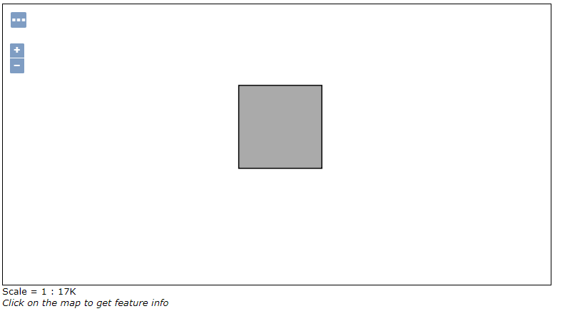
Go again to the Preview Layers section, locate stations2:Station and click on OpenLayers link, now GeoServer will display the nested polygons:
Change layer featureType name on GeoServer
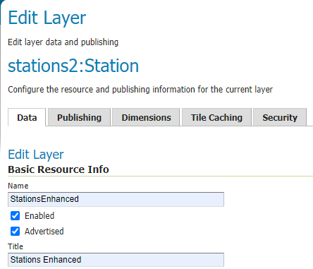
Now it is possible to change the layer name for App-Schema complex features. Go to the station2:Stations layer configuration page and change the Name to StationsEnhanced. Then click on save.
Go to the Preview Layers section, locate stations2:StationsEnhanced and click on OpenLayers link to double check the new layer name is working.