
Example n° 1: Serving a large number of GrayScale GeoTiff with Palette
In this example there is a group of Gray GeoTiff images. The purpose of this section is to describe how to merge these images using GDAL. These data are taken from the Regione Marche Cartographic Portal.
Note
On a Windows machine you can set-up a shell with all GDAL Utilities, running directly the file OSGeo4W.bat under the %TRAINING_ROOT% folder.
Note
Data have the same pixel resolution and same Coordinate Reference System EPSG:26592.
- Navigate to the workshop directory
$TRAINING_ROOT/data/user_data/gdal_processing_data(on Windows%TRAINING_ROOT%\data\user_data\gdal_processing_data) and find the grayscale_data directory. - Navigate inside the grayscale_data directory with the GDAL shell.
Note
The following operations must be executed from the shell inside the selected directory.
Calling the gdalinfo command on an image for retrieving the associated information:
gdalinfo 32501_.tif
And the result is:
Driver: GTiff/GeoTIFF
Files: 32501_.tif
           32501_.tfw
Size is 5494, 4526
Coordinate System is `'
Origin = (2356751.582169299000000,4762684.428062002200000)
Pixel Size = (1.269090000000000,-1.269090000000000)
Metadata:
  TIFFTAG_RESOLUTIONUNIT=2 (pixels/inch)
  TIFFTAG_XRESOLUTION=1200
  TIFFTAG_YRESOLUTION=1200
Image Structure Metadata:
  COMPRESSION=LZW
  INTERLEAVE=BAND
Corner Coordinates:
Upper Left  ( 2356751.582, 4762684.428)
Lower Left  ( 2356751.582, 4756940.527)
Upper Right ( 2363723.963, 4762684.428)
Lower Right ( 2363723.963, 4756940.527)
Center      ( 2360237.772, 4759812.477)
Band 1 Block=5494x1 Type=Byte, ColorInterp=Palette
  Color Table (RGB with 256 entries)
        0: 0,0,0,255
        1: 1,1,1,255
        2: 2,2,2,255

        ~

        254: 254,254,254,255
        255: 255,255,255,255
From gdalinfo it is possible to note:
- No CRS definition. An image without CRS cannot be displayed on GeoServer.
- Tiles Striped (5494x1).
- LZW Compression.
- ColorInterpretation as a Palette.
Using gdal_translate it is possible to change the ColorInterpretation from Palette to Gray.:
gdal_translate -expand gray -a_srs EPSG:26592 -of vrt {filename}.tif {filename}.vrt
The final image format is not GeoTiff but VRT. This format simply creates an XML file containing information about the operation to perform on the image; the output image is created only when the image must be shown to the screen. The CRS is set with the -a_srs parameter. The color interpretation can be set to gray because each palette value is equal to a grayscale value (this last step is optional).
Note
The expand gray option does not create a multi banded image but only one band is present.
Note
In future a possible operation could be the processing of the input image with the color interpretation set to gray and the calculation of the optimal palette on the final image.
For executing the same operation on all the input images a script called script.sh (Linux) or script.bat (Windows) must be created and executed:
Note
In order to edit the scripts use the basic notepad editor on Windows or gedit on Linux. Remember that on Linux, after the script creation, it must be marked as executable with the command
chmod +x <name_script>.shLinux:
#!/bin/bash FILES="*.tif" echo start for f in $FILES do echo $f gdal_translate -expand gray -a_srs EPSG:26592 -of vrt $f ${f:0:6}.vrt done echo stopWindows:
for %%F in (*.tif) do  (
 gdal_translate -expand gray -a_srs EPSG:26592 -of vrt %%F %%F.vrt
)
Creating a list of the VRT files:
ls *.vrt > list.txt (Linux)

or

dir /b *.vrt > list.txt (Windows)
Merging of all the input files with the gdalbuildvrt command:
gdalbuildvrt -srcnodata 255 -vrtnodata 255 -resolution highest -input_file_list list.txt merged_vrt.vrt
Parameters used:
- -srcnodata 255 -vrtnodata 255 : setting of the input and output image No Data.
- -resolution highest : selection of the highest image resolution.
- -input_file_list list.txt : definition of the input file list.
The result of calling gdalinfo on the output image is:
Driver: VRT/Virtual Raster
Files: merged_vrt.vrt
           32501_.vrt

           ~

           32507_.vrt
Size is 16342, 9157
Coordinate System is:
PROJCS["Monte Mario (Rome) / Italy zone 2 (deprecated)",
        GEOGCS["Monte Mario (Rome)",
                DATUM["Monte_Mario_Rome",
                        SPHEROID["International 1924",6378388,297,
                                AUTHORITY["EPSG","7022"]],
                        TOWGS84[-104.1,-49.1,-9.9,0.971,-2.917,0.714,-11.68],
                        AUTHORITY["EPSG","6806"]],
                PRIMEM["Rome",12.45233333333333,
                        AUTHORITY["EPSG","8906"]],
                UNIT["degree",0.0174532925199433,
                        AUTHORITY["EPSG","9122"]],
                AUTHORITY["EPSG","4806"]],
        PROJECTION["Transverse_Mercator"],
        PARAMETER["latitude_of_origin",0],
        PARAMETER["central_meridian",2.54766666666666],
        PARAMETER["scale_factor",0.9996],
        PARAMETER["false_easting",2520000],
        PARAMETER["false_northing",0],
        UNIT["metre",1,
                AUTHORITY["EPSG","9001"]],
        AXIS["X",EAST],
        AXIS["Y",NORTH],
        AUTHORITY["EPSG","26592"]]
Origin = (2356629.695870598300000,4762684.428062002200000)
Pixel Size = (1.267290000000000,-1.267290000000000)
Corner Coordinates:
Upper Left  ( 2356629.696, 4762684.428) (  0d32'36.59"E, 42d59'54.65"N)
Lower Left  ( 2356629.696, 4751079.854) (  0d32'48.78"E, 42d53'38.68"N)
Upper Right ( 2377339.749, 4762684.428) (  0d47'50.77"E, 43d 0' 9.65"N)
Lower Right ( 2377339.749, 4751079.854) (  0d48' 1.42"E, 42d53'53.63"N)
Center      ( 2366984.722, 4756882.141) (  0d40'19.38"E, 42d56'54.40"N)
Band 1 Block=128x128 Type=Byte, ColorInterp=Gray
  NoData Value=255
Transforming from VRT to GeoTiff with gdal_translate:
gdal_translate -co "BLOCKXSIZE=512" -co "BLOCKYSIZE=512" -co "TILED=YES" -co "BIGTIFF=YES" -co "COMPRESS=DEFLATE" merged_vrt.vrt merged_tif.tif
Warning
This operation might take many minutes.
Parameters used:
-co “BLOCKXSIZE=512” -co “BLOCKYSIZE=512” -co “TILED=YES” : setting tile dimensions.
-co “BIGTIFF=YES” -co “COMPRESS=DEFLATE” : (Optional) loss-less compression of the image for reducing the disk space occupation, similar to LZW.
Note
-co “BIGTIFF=YES” is used because GDAL is not automatically able to convert the GeoTiff image into a BigTiff if compression is set.
From gdalinfo:
Driver: GTiff/GeoTIFF
Files: merged_tif.tif
Size is 16342, 9157
Coordinate System is:
PROJCS["Monte Mario (Rome) / Italy zone 2",
        GEOGCS["Monte Mario (Rome)",
                DATUM["Monte_Mario_Rome",
                        SPHEROID["International 1924",6378388,297.0000000000014,
                                AUTHORITY["EPSG","7022"]],
                        TOWGS84[-104.1,-49.1,-9.9,0.971,-2.917,0.714,-11.68],
                        AUTHORITY["EPSG","6806"]],
                PRIMEM["Rome",12.45233333333333],
                UNIT["degree",0.0174532925199433],
                AUTHORITY["EPSG","4806"]],
        PROJECTION["Transverse_Mercator"],
        PARAMETER["latitude_of_origin",0],
        PARAMETER["central_meridian",15],
        PARAMETER["scale_factor",0.9996],
        PARAMETER["false_easting",2520000],
        PARAMETER["false_northing",0],
        UNIT["metre",1,
                AUTHORITY["EPSG","9001"]],
        AUTHORITY["EPSG","26592"]]
Origin = (2356629.695870598300000,4762684.428062002200000)
Pixel Size = (1.267290000000000,-1.267290000000000)
Metadata:
  AREA_OR_POINT=Area
Image Structure Metadata:
  COMPRESSION=DEFLATE
  INTERLEAVE=BAND
Corner Coordinates:
Upper Left  ( 2356629.696, 4762684.428) ( 12d59'44.99"E, 42d59'54.65"N)
Lower Left  ( 2356629.696, 4751079.854) ( 12d59'57.18"E, 42d53'38.68"N)
Upper Right ( 2377339.749, 4762684.428) ( 13d14'59.17"E, 43d 0' 9.65"N)
Lower Right ( 2377339.749, 4751079.854) ( 13d15' 9.82"E, 42d53'53.63"N)
Center      ( 2366984.722, 4756882.141) ( 13d 7'27.78"E, 42d56'54.40"N)
Band 1 Block=512x512 Type=Byte, ColorInterp=Gray
  NoData Value=255
This image can be displayed on GeoServer but a further optimization step could bring to better performances. There could be two ways for optimizing the GeoServer performances:
- building image overviews.
- building a pyramid of the image.
(Optional) Optimization.
Building overview with gdaladdo:
gdaladdo -r cubicspline merged_tif.tif 2 4 8 16 32
Overviews are reduced views of the input image used by GeoServer for displaying the image at a lower resolutions.
Parameters used:
- -r cubicspline : setting the interpolation mode to cubicspline (by default is nearest-neighbour).
- 2 ~ 32 : setting overview level.
And with gdalinfo:
Band 1 Block=512x512 Type=Byte, ColorInterp=Gray
  NoData Value=255
  Overviews: 8171x4579, 4086x2290, 2043x1145, 1022x573, 511x287
Then the result can be displayed in GeoServer by configuring the image as a GeoTiff (see Adding a GeoTiff section).
Building a pyramid through several gdalwarp invokations, each time by reducing the image resolution:
gdalwarp -r cubicspline -dstnodata 255 -srcnodata 255 -multi -tr 2.53458 -2.53458 -co BLOCKXSIZE=512 -co BLOCKYSIZE=512 -co TILED=YES -co COMPRESS=DEFLATE merged_tif.tif merged_tif_2.tif
Parameters used:
- -r cubicspline : definition interpolation method.
- -dstnodata 255 -srcnodata 255 : definition of the image input and output NO DATA.
- -multi : forcing to use multithreading.
- -tr 2,53458 -2,53458 : definition of the image resolutions.
Output image from gdalinfo:
Driver: GTiff/GeoTIFF
Files: merged_tif_2.tif
Size is 8171, 4578
Coordinate System is:

~

Band 1 Block=512x512 Type=Byte, ColorInterp=Gray
  NoData Value=255
After another gdalwarp on the output image:
gdalwarp -r cubicspline -dstnodata 255 -srcnodata 255 -multi -tr 5.06916 -5.06916 -co BLOCKXSIZE=512 -co BLOCKYSIZE=512 -co TILED=YES -co COMPRESS=DEFLATE merged_tif_2.tif merged_tif_4.tif
And gdalinfo:
Driver: GTiff/GeoTIFF
Files: merged_tif_4.tif
Size is 4085, 2289
Coordinate System is:

~

Band 1 Block=512x512 Type=Byte, ColorInterp=Gray
  NoData Value=255
The operations must be executed on the first image, then the same operation must be repeated on the output image and so on. This cycle allows to create a pyramid of images, each one with a lower resolution.
Then the result can be displayed in GeoServer by configuring the images as a pyramid (see Advanced Mosaic and Pyramid configuration section).
Displaying the result on GeoServer:
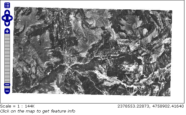
Result with gdaladdo
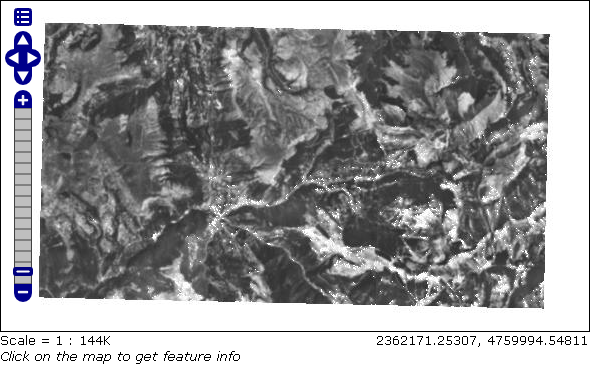
Result with ImagePyramid