
Defining the alignment
Once source and target schemas have been imported, it is time to define what HALE calls an alignment, i.e. a mapping between source and target schemas. An alignment defines relations between source and target entities (types or properties). First, relations between types must be established, and then relations between properties can be defined. Each relation is described by a function and it is visually represented in the alignment view by a mapping cell.
In the following example, the type t1 from the source schema is mapped to the type person in the target schema. The relation is represented by the Retype function

Creates a person instance for each t1 instance in the source data set
For more information on alignments, please read the relevant section in the HALE User Guide, accessible from the Help menu.
The land cover data stored in the database is organized in two different ways, to show different mapping strategies in action:
Three normalized tables:
- landcover_ds: contains information about the entire dataset, namely ID and extent
- landcover_lcu: each record in this table corresponds to a single land cover unit
- landcover_obs: each record in this table corresponds to a single land cover classification information, relative to a specific year
A one-to-many relationship exists between landcover_ds and landcover_lcu (a dataset may contain many units), as well as between landcover_lcu and landcover_obs (many observations may exist for the same unit).
A single denormalized table:
- landcover_denorm: a denormalized version of the three tables described above: dataset ID and extent are repeated for each record, and classification information for years 2007, 2010 and 2013 has been added to the table as separate columns.
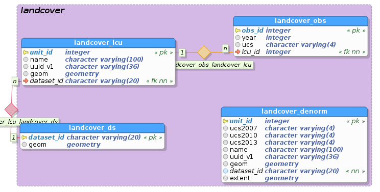
E/R diagram of the land cover schema
We would like to define the mapping so that the resulting GML will have LandCoverObservation, LandCoverUnit and LandCoverDataset elements properly nested inside each other: LandCoverDataset will contain related LandCoverUnit instances in its multi-valued member property, and LandCoverUnit will contain related LandCoverObservation instances in its multi-valued landCoverObservation property.
Enabling the GeoServer compatibility mode
Before starting to define the mapping, it is wise to enable the GeoServer compatibility mode, by selecting Transformation → Compatibility mode → GeoServer from the menu. You should now see the word Geo next to a green tick mark icon at the corner of the status bar on the bottom:
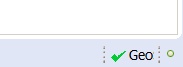
GeoServer compatibility mode is on, no incompatibility detected
As long as the compatibility mode is enabled, HALE will notify the user if the mapping cannot be translated to an app-schema configuration (as shown in the figure below), due, for example, to the use of an unsupported transformation function.
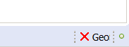
GeoServer compatibility mode is on, incompatibility was detected
Mapping the normalized tables
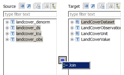
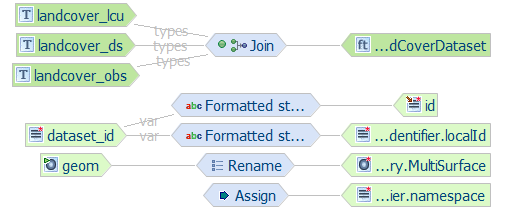
The three source tables, landcover_ds, landcover_lcu and landcover_obs, should be combined and mapped to a single target type, LandCoverDataset, using a Join relation.
This will translate to a target dataset having one LandCoverDataset instance for each record in the landcover_ds table, inside of which LandCoverUnit and LandCoverObservation instances are nested.
Joining landcover_ds, landcover_lcu and landcover_obs
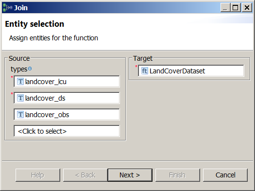
Select the landcover_ds, landcover_lcu and landcover_obs types in the Source section of the Schema Explorer view
Select the LandCoverDataset type in the Target section of the Schema Explorer view
Click on the blue double-pointing arrow icon in between the Source and Target sections of the Schema Explorer view and select Join from the popup menu
A wizard will open. Verify the first screen looks like the figure below, and click on the Next button:
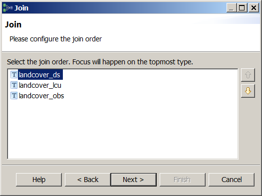
Configure the join order. The join order should follow the nesting order, i.e. the container (base) type should always precede the nested (join) type (see figure below).
For each pair of tables to join, define the join conditions, specifying which coloumns contain equal values (i.e. define a foreing key constraint).
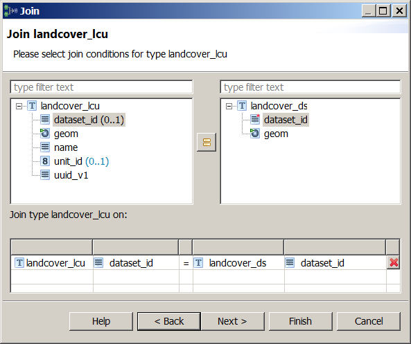
Join condition between landcover_ds (base type) and landcover_lcu (join type)
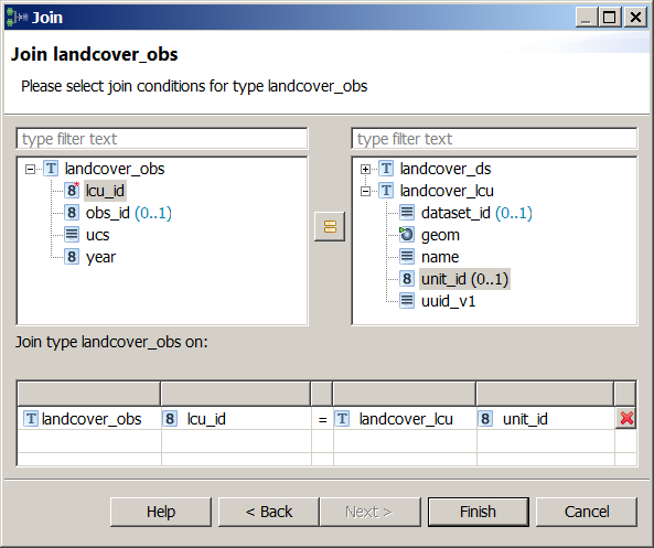
Join condition between landcover_lcu (base type) and landcover_obs (join type)
Note
In HALE, multiple join conditions can be specified for each source type, whereas the GeoServer App-Schema extension only supports single-condition joins; thus, in order to be translateable to a GeoServer App-Schema configuration, an alignment should not contain more than one join condition for the same source type.
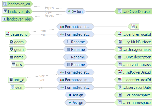
Click on the Finish button and the Alignment view should now look like the following:
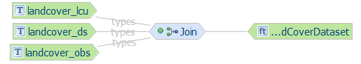
Join mapping is now complete
Now that the type relations have been defined, it is time to configure the relations between source and target properties.
Mapping landcover_ds to LandCoverDataset
The landcover_ds properties will be mapped to properties of the LandCoverDataset target type. We will use the dataset_id source property to populate both the gml:id and inspireId target properties, but, instead of using the value of the dataset_id property as is, we will prepend the string lcv. to it, using the Formatted String transformation function.
We will also use the geom source property to populate the extent target property.
Let’s start with the dataset_id property:
Select the landcover_ds/dataset_id property in the Source section of the Schema Explorer view
Select the LandCoverDataset/id property in the Target section of the Schema Explorer view
Click on the blue double-pointing arrow icon in between the Source and Target sections of the Schema Explorer view and select Formatted string from the popup menu
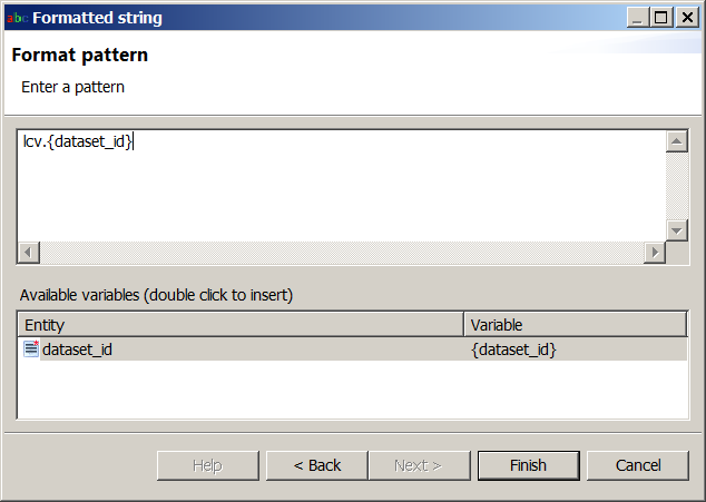
A wizard will open. Click Next on the first screen and, on the second screen, define the format pattern by typing lcv. and then double-clicking on dataset_id in the Available variables section, as shown in the figure below:
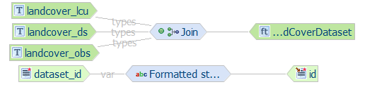
Click on the Finish button and the alignment should now look like the following:
Repeat the same steps to map the LandCoverDataset/inspireId/Identifier/localId target property
We will now assign a constant value to the LandCoverDataset/inspireId/Identifier/namespace target property, using the Assign transformation function.
Select the property in the Target section of the Schema Explorer view, click on the button in between the Source and Target sections of the Schema Explorer view and select Assign from the popup menu
A wizard will open. Click Next on the first screen and, on the second screen, type the value http://it.geosolutions.hale-training in the text field.
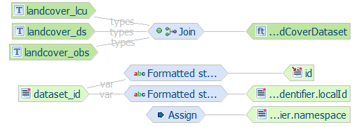
Click on the Finish button and the alignment should now look like the following:
Now we will directly map the geom source property, which contains the extent of the entire dataset, to the extent target property, using the Rename transformation function, which simply copies source to target.
Select the landcover_ds/geom property in the Source section of the Schema Explorer view
Select the LandCoverDataset/extent/EX_Extent/geographicElement/AbstractEX_GeographicExtent/ EX_BoundingPolygon/polygon/AbstractGeometry/MultiSurface property in the Target section of the Schema Explorer view
Note
Usually, it’s not necessary to map a geometry property down to the specific GML geometry type (in this case, MultiSurface), since both HALE and GeoServer are able to detect it automatically when the geometry is actually encoded, i.e. normally one would not select polygon/AbstractGeometry/MultiSurface as target property, but simply polygon; however, in this particular case, it is required, due to a GeoServer issue with the encoding of geometry properties that do not inherit from gml:GeometryPropertyType.
Click on the blue double-pointing arrow icon in between the Source and Target sections of the Schema Explorer view and select Rename from the popup menu
A wizard will open. Click on the Finish button and the alignment should now look like the following:
Mapping landcover_lcu to LandCoverUnit
The landcover_lcu properties will be mapped to properties of the LandCoverUnit target type. Be careful, though, because we will not pick the properties of the top level LandCoverUnit type (which is immediately visible in the Target section of the Schema Explorer view), but we will reach for the LandCoverUnit property nested under the member property of the LandCoverDataset type (see figure below), and map to its child properties.
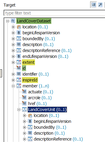
We want to map to the child properties of the LandCoverUnit property nested in the LandCoverDataset type
Since at this stage you should be familiar with the process of defining a relation, we will describe the required steps more succintly.
- Map the landcover_lcu/unit_id source property to the LandCoverDataset/member/LandCoverUnit/id and the LandCoverDataset/member/LandCoverUnit/inspireId/Identifier/localId target properties using the Formatted string transformation function. Use lcu.{unit_id} as format pattern.
- Map the constant value http://it.geosolutions.hale-training to the LandCoverDataset/member/LandCoverUnit/inspireId/Identifier/namespace target property using the Assign transformation function.
- Map the landcover_lcu/name source property to the LandCoverDataset/member/LandCoverUnit/description target property using the Rename transformation function.
- Map the landcover_lcu/geom source property to the LandCoverDataset/member/LandCoverUnit/geometry target property using the Rename transformation function.
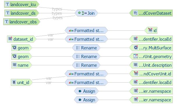
- The alignment should now look like the following:
Mapping landcover_obs to LandCoverObservation
The landcover_obs properties will be mapped to properties of the LandCoverObservation target type. Similarly to what we did for LandCoverUnit, we will not pick the properties of the top level LandCoverObservation type (which is immediately visible in the Target section of the Schema Explorer view), but we will reach for the LandCoverObservation property nested under the landCoverObservation property of the LandCoverUnit property, which is itself nested under the member property of the LandCoverDataset type (see figure below), and map to its child properties.
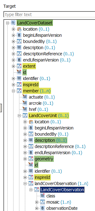
We want to map to the child properties of the LandCoverObservation property nested in the LandCoverDataset type
Define the following relations:
- Map the landcover_obs/ucs source property to the LandCoverDataset/member/LandCoverUnit/landCoverObservation/LandCoverObservation/class target property using the Rename transformation function.
- Map the landcover_obs/year source property to the LandCoverDataset/member/LandCoverUnit/landCoverObservation/LandCoverObservation/observationDate target property using the Formatted String transformation function. Use {year}-01-01 00:00:00.0 as format pattern.
- The alignment should now look like the following:
Mapping table overview (normalized)
The following table summarizes the mappings performed previously
| source property | target property | type of mapping |
|---|---|---|
| landcover_ds/dataset_id | LandCoverDataset/id | Formatted string (lcv.{dataset_id}) |
| http://it.geosolutions.hale-training | LandCoverDataset/inspireId/Identifier/namespace | Assign |
| http://it.geosolutions.hale-training | LandCoverDataset/inspireId/Identifier/namespace | Assign |
| landcover_ds/geom | LandCoverDataset/extent/EX_Extent/geographicElement/AbstractEX_GeographicExtent/EX_BoundingPolygon/polygon/AbstractGeometry/MultiSurface | Rename |
| landcover_lcu/unit_id | LandCoverDataset/member/LandCoverUnit/id | Formatted string (lcu.{unit_id}) |
| landcover_lcu/unit_id | LandCoverDataset/member/LandCoverUnit/inspireId/Identifier/localId | Formatted string (lcu.{unit_id}) |
| http://it.geosolutions.hale-training | LandCoverDataset/member/LandCoverUnit/inspireId/Identifier/namespace | Assign |
| landcover_lcu/name | LandCoverDataset/member/LandCoverUnit/description | Rename |
| landcover_lcu/geom | LandCoverDataset/member/LandCoverUnit/geometry | Rename |
| landcover_obs/ucs | LandCoverDataset/member/LandCoverUnit/landCoverObservation/LandCoverObservation/class | Rename |
| landcover_obs/year | LandCoverDataset/member/LandCoverUnit/landCoverObservation/LandCoverObservation/observationDate | Formatted string ({year}-01-01 00:00:00.0) |
Congratulations, the mapping is now complete. You can jump to the next section to learn how your alignment can be exported to an App-Schema mapping configuration and uploaded to GeoServer.
Mapping the denormalized tables
In the “normalized” version of the mapping we defined a Join relation between the three source types and the target type, LandCoverDataset; this time we have just one source type, landcover_denorm, so a Join relation doesn’t make sense.
We are left with two alternatives:
- Retype: establishes a 1:1 relationship between source type and target type, so for each instance of the source type, an instance of the target type will be created.
- Merge: establishes a N:1 relationship between source type and target type, so multiple instances of the source type will be merged into a single instance of the target type, based on one or more matching properties.
Since each record in the landcover_denorm table corresponds to a single LandCoverUnit instance, we are going to define a Retype relation between landcover_denorm and LandCoverUnit. Conversely, we would like to have just one LandCoverDataset instance for all records in the landcover_denorm table belonging to the same dataset (i.e. with the same dataset_id), thus Merge is the correct choice here. The resulting LandCoverDataset will reference its child LandCoverUnit instances via the xlink:href attribute of its multi-valued lcv:member property. Please note that we have no Join here, so the two feature types will not be chained by App-Schema (see Feature chaining configuration in the next section) and you won’t be able to filter a dataset based on the properties of the units contained in it.
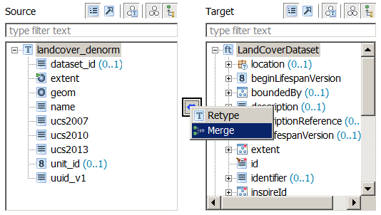
Merging landcover_denorm instances
The steps required to define the Merge relation are:
- Select the landcover_denorm type in the Source section of the Schema Explorer view
- Select the LandCoverDataset type in the Target section of the Schema Explorer view
- Click on the blue double-pointing arrow icon in between the Source and Target sections of the Schema Explorer view and select Merge from the popup menu
- A wizard will open. Verify the first screen looks like the figure below, and click on the Next button:
- Select dataset_id as the only matching property, as shown in the figure below:
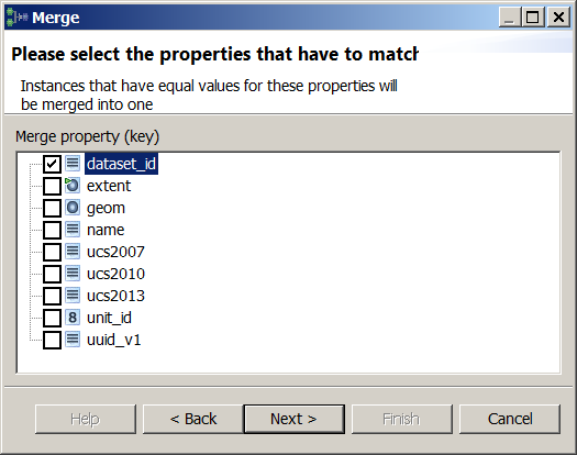
Note
Merge relations with multiple matching properties cannot be translated to a working App-Schema configuration, so you should always select just one property here.
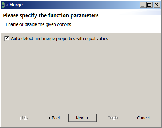
- In the next dialog, check the Auto detect and merge properties with equal values option, as shown in the figure below:
- Click on the Next button in the following wizard screens, until the last screen appears and you can click on the Finish button. The Alignment view should now look like the following:

Merge mapping is now complete
Mapping landcover_denorm properties (Merge)
Define the following relations (if you are not familiar with this process yet, check out the previous paragraphs):
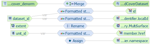
- Map the landcover_denorm/dataset_id source property to the LandCoverDataset/id and the LandCoverDataset/inspireId/Identifier/localId target properties using the Formatted string transformation function. Use lcd.{dataset_id} as format pattern.
- Map the constant value http://it.geosolutions.hale-training to the LandCoverDataset/inspireId/Identifier/namespace target property using the Assign transformation function.
- Map the landcover_denorm/extent source property to the LandCoverDataset/extent/EX_Extent/geographicElement/AbstractEX_GeographicExtent/ EX_BoundingPolygon/polygon/AbstractGeometry/MultiSurface target property using the Rename transformation function.
- Map the landcover_denorm/unit_id source property to the LandCoverDataset/member/href target property using the Formatted string transformation function. Use lcu.{unit_id} as format pattern.
- At this stage, the Alignment view should look like this:
Retyping landcover_denorm instances
The steps required to define the Retype relation are:
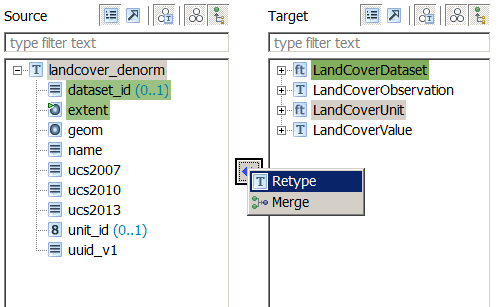
- Select the landcover_denorm type in the Source section of the Schema Explorer view
- Select the LandCoverUnit type in the Target section of the Schema Explorer view
- Click on the blue double-pointing arrow icon in between the Source and Target sections of the Schema Explorer view and select Retype from the popup menu
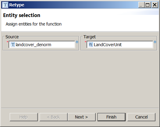
- A wizard will open. Verify the first screen looks like the figure below, and click on the Finish button:
- The Alignment view should now look like the following:

Retype mapping is now complete. Please note that you have to click on the LandCoverUnit type to have the Alignment view display the Retype relation
Mapping landcover_denorm properties (Retype)
Define the following relations (if you are not familiar with this process yet, check out the previous paragraphs):
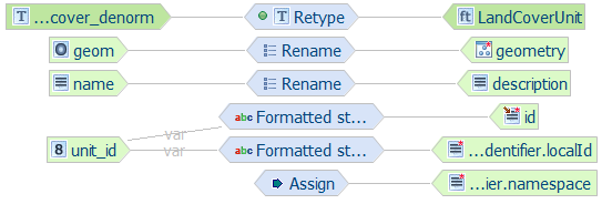
- Map the landcover_denorm/unit_id source property to the LandCoverUnit/id and the LandCoverUnit/inspireId/Identifier/localId target properties using the Formatted string transformation function. Use lcu.{unit_id} as format pattern.
- Map the constant value http://it.geosolutions.hale-training to the LandCoverUnit/inspireId/Identifier/namespace target property using the Assign transformation function.
- Map the landcover_denorm/name source property to the LandCoverUnit/description target property using the Rename transformation function.
- Map the landcover_denorm/geom source property to the LandCoverUnit/geometry target property using the Rename transformation function.
- At this stage, the Alignment view should look like this (make sure the Retype cell is being shown in the Alignment view):
Now we are going to map land cover observations. In the source type, we have three properties, ucs2007, ucs2010, ucs2013: for each one, we would like to create an instance of the multi-valued property LandCoverUnit/landCoverObservation.
To do so, we leverage a feature of HALE called instance context: an instance context can be defined on properties that may occur multiple times and represents an additional property instance that a mapping can use as a target, thus allowing the same target property to be populated from the source in different ways.
Follow these steps to create the required instance contexts:
- In the Target section of the Schema Explorer view, navigate to the LandCoverUnit/landCoverObservation property.
- Right-click on the property name and select Add instance context from the popup menu (see figure below).
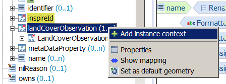
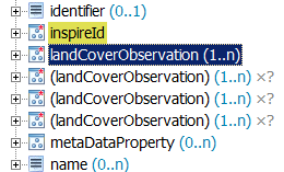
- Repeat the previous step two times more, and now three copies of the landCoverObservation property should be visible in your Schema Explorer view:
We are now ready to define the missing relations:
- Map the landcover_denorm/ucs2007 source property to landCoverObservation/LandCoverObservation/class target property of the first instance context, using the Rename transformation function.
- Map the constant value 2007-01-01 00:00:00.0 to the landCoverObservation/LandCoverObservation/observationDate target property of the first instance context, using the Assign transformation function.
- Map the landcover_denorm/ucs2010 source property to landCoverObservation/LandCoverObservation/class target property of the second instance context, using the Rename transformation function.
- Map the constant value 2010-01-01 00:00:00.0 to the landCoverObservation/LandCoverObservation/observationDate target property of the second instance context, using the Assign transformation function.
- Map the landcover_denorm/ucs2013 source property to landCoverObservation/LandCoverObservation/class target property of the third instance context, using the Rename transformation function.
- Map the constant value 2013-01-01 00:00:00.0 to the landCoverObservation/LandCoverObservation/observationDate target property of the third instance context, using the Assign transformation function.
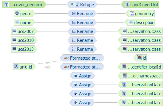
- Your Alignment view should now look like the following (make sure the Retype cell is being shown in the Alignment view):
Mapping table overview (denormalized)
The following table summarizes the mappings performed previously
| source property | target property | type of mapping |
|---|---|---|
| Merge Mapping | ||
| landcover_denorm/dataset_id | LandCoverDataset/id | Formatted string (lcd.{dataset_id}) |
| landcover_denorm/dataset_id | LandCoverDataset/inspireId/Identifier/localId | Formatted string (lcd.{dataset_id}) |
| http://it.geosolutions.hale-training | LandCoverDataset/inspireId/Identifier/namespace | Assign |
| landcover_denorm/extent | LandCoverDataset/extent/EX_Extent/geographicElement/AbstractEX_GeographicExtent/EX_BoundingPolygon/polygon/AbstractGeometry/MultiSurface | Rename |
| landcover_denorm/unit_id | LandCoverDataset/id | Formatted string (lcu.{unit_id}) |
| Retype Mapping | ||
| landcover_denorm/unit_id | LandCoverUnit/id and the LandCoverUnit/inspireId/Identifier/localId | Formatted string (lcu.{unit_id}) |
| http://it.geosolutions.hale-training | LandCoverUnit/inspireId/Identifier/namespace | Assign |
| landcover_denorm/name | LandCoverUnit/description | Rename |
| landcover_denorm/geom | LandCoverUnit/geometry | Rename |
| landcover_denorm/ucs2007 | landCoverObservation/LandCoverObservation/class | Rename |
| 2007-01-01 00:00:00.0 | landCoverObservation/LandCoverObservation/observationDate | Assign |
| landcover_denorm/ucs2010 | landCoverObservation/LandCoverObservation/class | Rename |
| 2010-01-01 00:00:00.0 | landCoverObservation/LandCoverObservation/observationDate | Assign |
| landcover_denorm/ucs2013 | landCoverObservation/LandCoverObservation/class | Rename |
| 2013-01-01 00:00:00.0 | landCoverObservation/LandCoverObservation/observationDate | Assign |
Note
Source properties items marked in italic are created using the instance contexts.
Congratulations, the mapping is now complete. You can jump to the next section to learn how your alignment can be exported to an App-Schema mapping configuration and uploaded to GeoServer.