DomainSet and Subsetting
The collection description also links to DomainSet, describing the detailed n-dimensional space covered by the data (referencing system, axis definitions, and grid limits).
The DomainSet can be retrieved as a JSON content at:
http://localhost:8083/geoserver/ogc/coverages/v1/
collections/sf:sfdem/coverage/domainset?f=application%2Fjson
JSON DomainSet
The following is the JSON output for the above DomainSet call:
{
   "type":"DomainSetType",
   "generalGrid":{
    "type":"GeneralGridCoverageType",
    "srsName":"http://www.opengis.net/def/crs/EPSG/0/26713",
    "axisLabels":[
     "E",
     "N"
    ],
    "axis":[
     {
      "type":"RegularAxis",
      "axisLabel":"E",
      "resolution":30.0,
      "lowerBound":589980.0,
      "upperBound":609000.0,
      "uomLabel":"m"
     },
     {
      "type":"RegularAxis",
      "axisLabel":"N",
      "resolution":30.0,
      "lowerBound":4913700.0,
      "upperBound":4928010.0,
      "uomLabel":"m"
     }
    ],
    "gridLimits":{
     "type":"GridLimitsType",
     "srsName":"http://www.opengis.net/def/crs/OGC/0/Index2D",
     "axisLabels":[
      "i",
      "j"
     ],
     "axis":[
      {
         "type":"IndexAxis",
         "axisLabel":"i",
         "lowerBound":0,
         "upperBound":633
      },
      {
         "type":"IndexAxis",
         "axisLabel":"j",
         "lowerBound":0,
         "upperBound":476
      }
     ]
    }
   }
}
Subsetting
The previously mentioned DomainSet resource allows to retrieve axis names and geospatial extent for a particular coverage. From the above example we know axis names (E,N) and their extent.
Subsetting allows to request a subset of the DomainSet, by specifying reduced ranges for named axes.
So we can setup a subset request with a reduced extent of 10km by 10km on a specific area to be returned as a GeoTIFF:
http://localhost:8083/geoserver/ogc/coverages/v1/
collections/sf:sfdem/coverage?f=image%2Fgeotiff&subset=E(590000:600000),N(4915000:4925000)
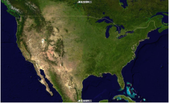
This is a request of a full coverage (no subset being specified) requested in PNG:
http://localhost:8083/geoserver/ogc/coverages/v1/
collections/nurc:Img_Sample/coverage?f=image%2Fpng
which results into this:
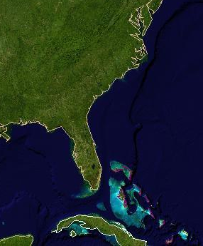
This is a request of the same coverage with subset specified to cover a 20 degrees by 20 degrees region:
http://localhost:8083/geoserver/ogc/coverages/v1/
collections/nurc:Img_Sample/coverage?f=image%2Fpng&subset=Lat(20:40),Long(-90:-70)
which results into this: